07/18/05: The coast of Maine
We left the Calais Motor Inn and bought some fruit, and had a fruitless search for an AOL disk.
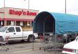
Maine protects its shopping carts!
--Click to Enlarge--
Although we had planned to jump across the bridge into New Brunswick, we decided to move slowly and see the low tide here in Maine before moving on.
I tried to get online at the Public Library, but after being surly with their expert, I found out that the only way I could do it is with one of their carrel computers: WinNT4.0 on a 486! No way to upload pictures. I just did a quick email check while Karen went to check out the McDonalds Lobster Rolls. Locals told her where to go to get good ones. Then Karen apologized to the poor librarian for my manners.
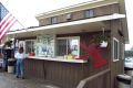
So we lunched at an ice cream stand on U.S. 1 called The Scream House and had the Lobster roll plate with onion rings.
The Scream Shack! Barely visible under the last coat of paint, an appropriate name for this ice cream and lobster dispensary
--Click to Enlarge--

Karen gets a Lobster Roll at an ice cream shack recommended by the locals
--Click to Enlarge--
Onion rings and a lobster roll (lobster salad on a bun) in Calais, Maine
--Click to Enlarge--

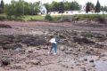
Then we stopped at a few shore access points to see the low tide, and look around the rocky beaches.
This milestone is one of a complete series of 15 set up by a newspaper man to time his horses, a generation before the first motor car hit this continent.
--Click to Enlarge--

Karen shows off a low-tide find: Dead crab, partially decomposed. Yum!
--Click to Enlarge--

Watching snails race among the karageenan at low tide on the coast of Maine
--Click to Enlarge--
Barnacles. Some alive and waiting for the tide to come on, some dead. They "clam up" tighter when touched.
--Click to Enlarge--

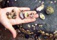
Karen shows off some of her finds
--Click to Enlarge--
To get drinking water in this park, one has to "pump it up".
--Click to Enlarge--

We drove on down to Lubec, Maine, where the Visitor centers closed at 3 on Monday, to open on Wednesday. But the Lubeck historian showed up after hours & Karen talked her way in.
It gives one a sense of accomplishment to me halfway, 5,000 kilometers from equator and pole.
--Click to Enlarge--

I don't know why Karen was so fascinated by this anti-salvage labeling
--Click to Enlarge--

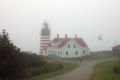
We drove to the West Quoddy Head lighthouse in dense fog, and stood at the easternmost point of the United States.
Quite a view of the Bay of Fundy from the eastern end of Maine
--Click to Enlarge--
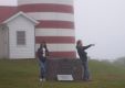
Sign says we're as far east as we can get and be in the U.S. Dan points east.
--Click to Enlarge--
Caged Karen in foggy lighthouse scene.
--Click to Enlarge--

The next couple of hours we spent trying to find an unnamed "Blow hole" at an unspecified location. Different locals had different ideas about how to get there, and it wasn't on any map.
Split logs offer Some support on this narrow trail through this marshy Nature Conservacy rainforest land.
--Click to Enlarge--

At the end of the Brook Beach trail, the foggy split of land ahead booms as waves focus into a "blow hole". Distant booms in dense fog.
--Click to Enlarge--

We stayed at the Eastland Motel just west of Lubec, where the owner gave us directions to a hike to what may or may not be the fabled blow hole.
I was very exhausted by the end of this day.