05/18/06: Day 5: Brown Rocks
First, expressing frustration: There is WiFi at this trailer park by the turn-off to Canyonlands National Park on the Colorado Plateau in Utah, but at the far corner. In order to check email and upload these logs, I found out that the antenna is on the bathhouse at the far end. Anywhere between Jade and John's trailer and the bathhouse it was too bright to see my screen. So, I sat on the bathhouse porch, leaned against the clapboard wall, and squinted to see my screen as I checked mail and uploaded pictures. I also uploaded a subtly "improved" trip script. I'd rewritten part of it last night, and it worked perfectly on my machine. I uploaded it, and it gave me a generic error message. I tried a few things, but my trip blog was hosed. I had to appeal to the support people by email, and wait. My uncomfortable connection time essentially wasted! I made a rookie mistake by not preserving my older script. Frustration.
My lack of sleep may have something to do with my mistakes. Our air mattress squeaked operatically on the kitchen floor every time either of us moved. The next night, we used a sheet under it!
(Obviously, I did finally get things to work. It had to do with server permissions, and incompatibilites between servers and clients).
On to Arches
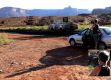
Jade snaps a picture
--Click to Enlarge--

Local lizard lounges. This monster is about 2½" long
--Click to Enlarge--

Karen takes a picture of Dan taking a picture, but of what? (Next picture)
--Click to Enlarge--

This picture of a desert flower is the picture that Dan took as Karen took the previous picture of him taking this one...
--Click to Enlarge--
Dan and his camera and the vary-colored horizon
--Click to Enlarge--
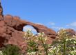
Dan looking up in a window (photo by Karen)
--Click to Enlarge--

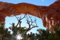
Dan took a picture looking up at the arch through the cedar you can barely make out in the bottom of the previous picture (that Karen took of Dan up under this arch)
--Click to Enlarge--
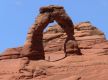
A 550mm long shot (35mm equiv) of the "Delicate Arch" made by resting my new camera on a rock at the top of the long, steep trail to see the arch at a distance. Note the human underneath for the scale of this unofficial Utah state emblem.
--Click to Enlarge--
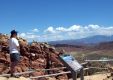
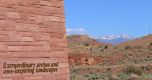
A scene from the Arches Visitor's Center near the end of the day. Red rocks and white mountains
--Click to Enlarge--
We drove to Arches, did a quick look at the Visitor's Center, and then started driving along the access road.
John, from the backseat, was fond of kvetching, "What? Another stop just to look at brown rocks?"
After the forth time, he dropped his (originally very expensive) digital camera on the pavement. It is no longer reliable. A moment of silence -- quit that chuckling!
We spent all day looking at these formations.
I accidentally learned (by connecting the interpretive displays at Arches with my years of stochastic study) why oil explorers look for salt domes. It is related to how parts of this region were formed, and how salt lakes and salt flats form, and many other interconnected geological observations from the knowledge that allows us to know how the top of the slag crust that we live on continues to evolve.
So, more pictures:
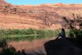
Karen relaxes by the Colorado River on the dead-end road down to Potash, Utah.
--Click to Enlarge--
One of a group of artists who arrived at the dead-end spur along the Colorado to Potash in a Prius.
--Click to Enlarge--
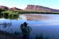
Karen snaps a shot of one of the many climbers/rapellers who use the steep cliffs along the Colorado for recreation
--Click to Enlarge--

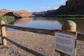
Dire warnings about the Colorado River at a recreation area
--Click to Enlarge--
Karen ignores the posted warnings in order to chill her feet in the Colorado River. She is not kicking her feet; the current is THAT strong right at the bank.
--Click to Enlarge--

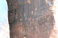
Petroglyphs from several hundred years before Europeans started climbing here. This is specifically labeled as a no-climb zone, as the glyphs are about 20 feet above the current road level.
--Click to Enlarge--
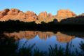
I just like reflections, like these sandstone hills in the Colorado River
--Click to Enlarge--
John hopefully tries to snap a shot of a calibrated test car on the rail line between Potash and Moab, Utah. I like shadows.
--Click to Enlarge--