09/29/10: Day 6: Montana, across Idaho, and into Washington
I'm sitting on the veranda of our little room in the Columbia River Inn looking up at the spillway of the Grand Coulee Dam as the last of the sun paints the hilltops across the river orange. We arrived in town barely in time to catch the last dam tour of the day. Nine-eleven did a number on such tours, but after the metal detector and prohibited items inventory, it went pretty well. We toured Power House Three, the afterthought addition that has a capacity of well over 4 Gigawatts. (42,000,000 100 watt bulbs, or two 2GW nuclear power plants). This is the biggest dam in the U.S, and the largest capacity hydoelectric plant.
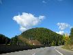
We started the day in Missoula, Montana, a town we'd previously stayed in and enjoyed in 2003. This time, we just spent the night, and drove west. We followed I-90 over another pass, and into Idaho and Pacific Time.
Cruising from Missoula toward Idaho, I saw this hill with a bad haircut. I kinda liked it.
--Click to Enlarge--
Lookout Pass on the border of Idaho and Montana. Elevation 4,860
--Click to Enlarge--

And on into Idaho
--Click to Enlarge--

We stopped in Kellogg, Idaho. I toured a mining museum while Karen rested on a porch and then walked over to find Espresso. The Staff House Mining Museum was getting ready to shut down for the season. Friday would have been too late. This was a silver and lead mining town for a century and a half. Most exhibits were typical, but I was impressed by a hand-drawn 3-D map of the mine done on layers of acetate film stretched on a home-made rack by a mine engineer. One could walk around this model and really see the shapes of the lodes.
Stopped in Kellogg, ID to see the Mining Museum on its penultimate day of the season. I like old tools. I already have both of the gizmos shown on the safe in my house.
--Click to Enlarge--
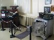
Under that glass tabletop there is a 3-D model of the mine. A mine engineer painstakingly drew maps of each level of the mine, dozens of large acetate sheets carefully stretched on a rack in a virtual stack. It didn't photograph well, but was way cool to see the mine in 3-D. I rocked side to side to see the shape of the lodes and the tunnels.
--Click to Enlarge--
This time clock controlled stuff. (Next pic)
--Click to Enlarge--

Those slotted and tabbed disks turned switches on an off on weekly and hourly schedules. Electromechanical things are fun.
--Click to Enlarge--
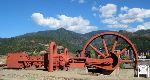
Back before electro-mechanical, there was the belt-driven air compressor. This 1890's Nordberg sits behind the Kellogg Mining Museum. Notice the gondola through the spokes? Shut down between summer hikers and winter skiers. Phooey.
--Click to Enlarge--
How many of these tools do you know? Crucibles, ingot molds, carts, and other tools of the silver mining trade.
--Click to Enlarge--
How would you like to commute to work in this cozy cart a few thousand feet underground?
--Click to Enlarge--
Karen had less luck. All the coffee places were done for the season. A waitress in a resort restaurant told us where to find good coffee in Coeur d'Alene, a half hour farther along our way.
We regularly reminded that this is timber country. Note the replanted hillside.
--Click to Enlarge--
Honey Bucket?
--Click to Enlarge--
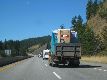
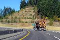
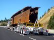
I like seeing where things come from. Here are a couple of bridge girders on the road. Notice that the load itself comprises the connection between the tractor and trailer. 50 wheels, if you'd care to count them.
--Click to Enlarge--
Maybe you've heard of it. A nice tourist resort town on a lake.
--Click to Enlarge--
We stopped for lunch, coffee and internet.
--Click to Enlarge--
After some misdirection, we found the Bakery, and had lunch and coffee. Then we wended our way westward into Washington State.
And on into Washington
--Click to Enlarge--
I like mirages
--Click to Enlarge--

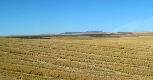
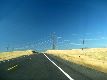
I'm guessing, wheat. Don't know what mountains those are in the middle of Washington. Probably part of the Cascades range.
--Click to Enlarge--
We left the interstate just past Spokane, and headed north.
--Click to Enlarge--
We are heading toward the biggest hydroelectric dam in the country.
--Click to Enlarge--
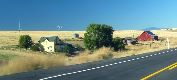
Agrarian family homesteads do still exist. But most of the ones we passed have been rotting ruins.
--Click to Enlarge--
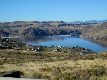
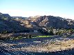
Heading down to Grand Coulee Dam. That's Franklin Delano Roosevelt Lake, the other end of it is in Canada. Big dam lake.
--Click to Enlarge--
We zipped through the traffic of Spokane and then left the interstate onto US-2. We headed up 2 to county road 174 to the Grand Coulee Dam. Yes, another damn Dan dam stop. I'd toured several dams, and am interested in how each is presented to the public. Plus, I am a guy who likes gadgets from nano to mega. This is mega.
We barely made the last tour of the day, but got to see the middles of both running and stopped-for-maintenance generators. Actually, when I saw how tight the time was, I was ready to give up. But Karen hustled me into the car and we raced across town to the other side of the dam to catch the tour. If you want details of the dam, try the link above. But reading about or seeing pictures doesn't convey the feeling of the rumble of gigawatts being converted a few feet away. This is basically a 360 foot high waterfall on the second largest river on the continent, barely contained by pipes and turbines under the most careful management. Very impressive, up close.
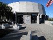
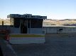
Grand Coulee Dam visitor's center.
--Click to Enlarge--
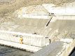
I noticed the way they used the natrual rock as much as possible, as in this wall.
--Click to Enlarge--
Karen took some snapshots as I was taking in the dam. The youth in shades is our guide on the free tour of the third power plant and the dam.
--Click to Enlarge--

Unfortunately, the cool elevator approach that comes down this track wasn't working. We came by van from the security gate.
--Click to Enlarge--

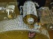
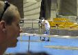
Our blurry guide gives us some of the numbers. They are working on this turbine. The hardhat is lowering equipment to the men down the hole. That disc in the floor is the spindle cover. We're talking big equipment.
--Click to Enlarge--
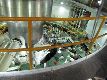
See the guys working on the turbine controls. The shaft is the spindle, the dynamo (generator) is above, and the turbine is below.
--Click to Enlarge--
This is actually one of the 4 small generators in this 3rd power plant. There are two larger ones in this building, too. Note the 600,000 kw? That's six million 100 watt bulbs from this one generator. This one powerhouse can develop over 4.2Gw (call it 2 nuclear power plants).The whole damn dam can currently produce over 7 gigawatts. And they are planning to install bigger, more efficient dynamos.
--Click to Enlarge--

They have plenty of security. We had a guard in attendance throughout the tour.
--Click to Enlarge--
Turning feet of water into watts, these glowing lines keep L.A. hair dryers running.
--Click to Enlarge--
Karen looks out over the Columbia River, nearly 400 feet below.
--Click to Enlarge--

Dan sees what he can see. Note Karen's shadow along my leg.
--Click to Enlarge--

That visitor's center looks small from up on the dam.
--Click to Enlarge--
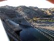
Another view of that non-functioning tour elevator. Also note the curved concrete pipes that carry the water to the turbines.
--Click to Enlarge--
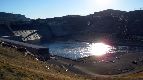
Oblique light strikes the dam as the sun glints off the water
--Click to Enlarge--
Light and shadow over Grand Coulee Dam
--Click to Enlarge--

At night, they open the spillway gates a crack and let merely millions of gallons flow down the dam to make a foaming, white screen for a laser show. The rumble of a sheet of water 350 feet tall, 1600 feet wide, and a foot thick impressed me. And looking up through the fan of lasers to see the milky way was fun. It is just barely dark enough here to see our galaxy. This nightly show runs through Sept 30, and starts again in May. We just made it.
So I decided to just stay in the dam town, at a hotel built on the spot where the Engineers Village was when the thing was built. Karen made sure they had a working hot tub, but as with many stays, didn't have the energy to go use it.
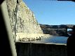
See the dam through the window of our motel room.
--Click to Enlarge--

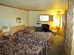
It was a nice room, a nice balcony, and a good place to stay.
--Click to Enlarge--
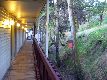
The charming "hallway" to our room
--Click to Enlarge--
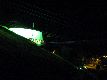
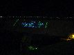
Every summer night (till Sept 30) they open the flood gates to create a white froth of water for a laser show about the history of the river and the dam.
--Click to Enlarge--
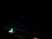
I had a tripod, so you can make out the big dipper as well as some of the lasers coming from the Grand Coulee Visitor's Center
--Click to Enlarge--
The show points out how significant this project was for the nation as a whole.
--Click to Enlarge--
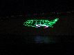
A better view of the lasers?
--Click to Enlarge--