10/10/11: Day 11: From Jackson Hole thru Idaho, and south to Little America
A day of moseying from Jackson Hole to Little America, 213 miles down the Snake River Canyon along the Idaho-Wyoming border. Much is explained in the picture captions.
Our last morning in the Tetons starts with breakfast at the diner adjacent to our hotel in Jackson Hole. Chafing dishes of eggs and sausage and such. Not very impressive, but included with the room. I did like the trompe l'oeil at the end of the room, though.
--Click to Enlarge--
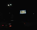
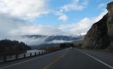
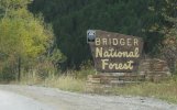
So we headed south out of Jackson, WY on US-89/26/191/189 toward Hoback and Alpine. These highways all merge at Jackson, and splay out to follow various downhill valleys. We follow US-89 along the Snake River. As it is still construction season, the lighted sign warns of 14 miles of gravel road ahead.
--Click to Enlarge--
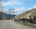
What is rad construction without bridge construction? This stuff fascinates me. Note the lacy arch under the bridge over the Snake River here.
--Click to Enlarge--
As we drive along the Snake River Canyon here at 10 in the morning, there is some interesting fog, or clouds. When you are over a mile high, the difference is moot. I wanted to stop to watch and time lapse the traveling clouds.
--Click to Enlarge--
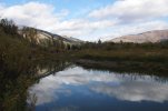
So we stopped at a convenient spot, and there happened to be a beaver dam. I enjoyed my time exploring the pond, a popular watering hole for elk and deer and smaller things, according to the tracks I saw
--Click to Enlarge--
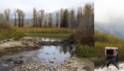
A pretty beaver pond on a nice morning right off US-89 in the Snake River Canyon
--Click to Enlarge--
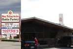
In the town of Thayne there was a well marked cheese factoryl. But when we pulled up to it, it had turned into a fudge factory after the market crash of 2008. So we visited the Bear Hug Fudge factory.
--Click to Enlarge--
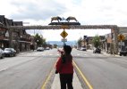
We noted on the map that Afton was the next town. That is the same name as one of the St. Louis exurbs! We decided beforehand to stop and take a picture. Good thing we did, as you will see.
--Click to Enlarge--
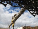
Afton turned out to be a tourism and arts community. Many art and craft shops, and many hiking, hunting, and outdoors-man outfitters. But the antlers were impressive.
--Click to Enlarge--
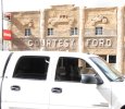
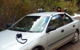
Courtesy Ford, courteous dog. Welcome to Afton, WY
--Click to Enlarge--
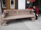
Convenient seating for spouses of shoppers are an appreciated amenity
--Click to Enlarge--
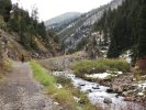
We were talking to a local artist in Afton, WY, and he asked if we'd been to "the geyser". He explained that it was the largest periodic spring in the world. After Yellowstone, we then had to find it. He said that it's just east of town, and told us where to turn. So we drove through the residential area, and then followed County Road 138 along swift creek. And it ended. No signs, but there appeared to be a path beyond the dead end...
--Click to Enlarge--
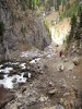
So we walked along the Swift Creek (I looked it up later) for quite a while. After 15 minutes we considered turning back. But we climbed onward. 40 minutes along the trail, we finally see...
--Click to Enlarge--
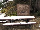
...a sign. But from here we can hear a waterfall. Still no indication of a "geyser."
--Click to Enlarge--
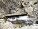
We climb up along the falls a couple of hundred feet, and I set up a time lapse, just in case the waterfall actually changes. We hadn't yet seen any difference in the hour we'd been following the water.
--Click to Enlarge--
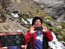
Just for grins, and playing with my new Droid, and possibly for the edification of my geo-caching friends, here's our coordinates: 42°44.716N and 110°50.961W
--Click to Enlarge--
After watching for 20 minutes, Karen decides to slide back down along the waterfall. I tell her that I would quickly check upstream to see if there is anything interesting. Note the circled time lapse camera (where we had been waiting) still hoping to record something interesting.
--Click to Enlarge--
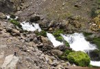
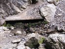
Just after I get to the top, the water flow stops. I set my other camera up to film it when it starts, and climb around this slightly improved area taking snapshots and video clips with my Droid. The straight shelf is artificial, but one can see the natural cave by peering into the hole.
--Click to Enlarge--
Here is a frame from the video halfway through the water flow coming back on. I am standing above the icy gusher taking a video with my phone. Eventually I hope to make an interesting video about this really cool place.
--Click to Enlarge--
I take video along the entire climb back down the waterfall and over to the car. Then set up the car to film the drive back to Afton. Do I have enough cameras?
--Click to Enlarge--
A last shot of Afton, WY less than three hours after arriving.
--Click to Enlarge--

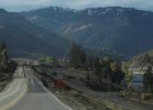
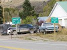
Three buildings make a town out here on the Wyoming/Idaho borderland. Smoot is the last town before the Salt River Pass
--Click to Enlarge--
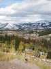
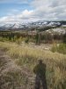
Up at the Salt River Pass at 7,630 feet, there is a pull out to enjoy the scenic view. As we arrive, there is a car there, with a middle aged Asian man listening to Opera. I set up a time lapse for the scudding clouds and waving grasses, and he leaves.
--Click to Enlarge--
Coming from the north, we had no information about the Periodic Spring. We'd have missed it if not for stopping and schmoozing with shopkeepers. Coming from the south, there are signs.
--Click to Enlarge--
Another photo for my album The Artist as a Void in the Landscape \(http://www.facebook.com/media/set/?set=a.3290928567140.108006.1685526085&type=1\)
--Click to Enlarge--
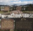
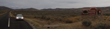
We drove down 89 into Idaho and back out, and then on US-30 to Co Rd 300 to Fossil Butte National Monument arriving at the visitor's center just as the ranger was closing up. He allowed us a quick run through the museum, and then we headed out. We enjoyed our barely longer visit here back in October 2003 (a trip that has yet to be put online).
--Click to Enlarge--
We had planned to stay in Kemmerer (home of J.C. Penney). But we got there after 6, and the town was full up and essentially closed. So we resigned ourselves to heading down Little America \(http://wyoming.littleamerica.com/accommodations/standard-rooms\) on I-80. We have been diligently avoiding interstates, but we needed a room.
--Click to Enlarge--