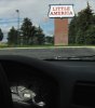
10/11/11: Day 12: Little America to Shoshoni, WY
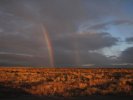
I woke up our Deluxe room in Little America at 6, and Karen was up by 7:30. She noted interesting light thru the gap in the curtains that I'd opened so I could see my keyboard. So I bundled up and ran outside with my SX-20. There I saw a rainbow! Good portent. Well, the lower leg of one was a sharp double in the low morning light. I got good and chilled shooting the waxing and waning rainbow with my Canon until it faded.
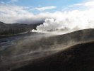
As Old Faithful relaxes again (and I'd taken many pictures which I've spared you) I notice the steaming landscape with the snowy trees beyond.
--Click to Enlarge--
Waking up in Little America I wrote up some notes about the previous day, and got dressed and such. Then Karen woke and remarked that the light was weird though the narrow slit in the curtains that I'd barely opened so that I could see the keyboard. So I ran outside and spent a half hour admiring the double rainbow in the early morning light.
--Click to Enlarge--
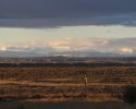
Looking away from the rainbow, and across I-80, there is the snowy mountain range to the north.
--Click to Enlarge--
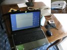
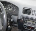
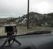
I am old enough to have traveled with a laptop and alligator clips to connect to Compuserve (back before AOL) via my 300 baud modem. The WiFi at Little America was iffy, but the phones had both modem and Ethernet jacks.Note that there are four computers on the table, each with more computational ability than NASA had access to when they put a man on the moon. Yes, the cameras have impressive processors and big memories, too.
--Click to Enlarge--
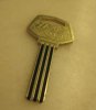
This must be an evolutionary missing link between brass motel keys and plastic key cards.
--Click to Enlarge--
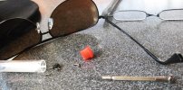
After a bit more computer puttering while Karen got us packed up, we had breakfast with pancakes at the town restaurant. As Karen checked us out, I cleared out the glove box to not-find an eyeglass repair kit for Karen's lens and my sunglass nose piece. So we shopped the L.A. convenience store and I fixed our glasses. We finally got on the road at 10:40.
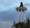
Of course "Little America \(http://en.wikipedia.org/wiki/Little_America_(exploration_base)\)" evokes penguins. So they provide some.
--Click to Enlarge--
Karen gassed up the car, and did some grocery shopping while I fixed my sunglasses.
--Click to Enlarge--
Note the odometer. This figured in our plans for the day.
--Click to Enlarge--
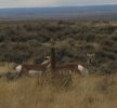
It was only 15 miles on I-80 to the next exit, and we turned north on WY-372, the La Barge Road. This was, in part so that we won't be on interstate for 200,000 mile event. So we stopped to take pix of the odometer and antelope at 199999, and stopped again to capture for disinterested posterity the odometer at 200,000. Right by the Seedskadee National Wildlife Refuge, where we mostly saw mining trucks.
We finally saw some pronghorns out here! We've been missing all the wildlife this trip.
--Click to Enlarge--
We pulled over to see the prairie jumpers just before we planned to stop anyway. Again, odometer check.
--Click to Enlarge--
Pop the bubbly! We hit 200,000 miles out in the middle of Wyoming. No actual booze was consumed. But we revel in knowing that approximately half of those miles came from seeing America in this car.
--Click to Enlarge--
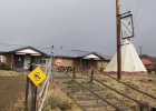
Then we turned up WY-28 toward: Atlantic City, Atlantic City here we come. Yes, we drove though scattered showers up a fast but rolling highway to a barely marked side road that turned to dirt after a few yards. I enjoyed driving the muddy road in light rain, up and down and zig and zag to Atlantic City. Karen was not as blase. The old mining town, named for its perch on the eastern side of the continental divide, was shut down for the winter. Almost. The town gathering place, bar, and grill was still open for a week. But the proprietress had just moved here six weeks ago, and hadn't yet absorbed enough of the local lore to inform tourists. But she suggested that we go back to South Pass City at the other end of this dirt road, where an old-timer ran a shop and National Historic Site. She warned that that lady would talk our ears off.
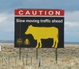
Moo
--Click to Enlarge--
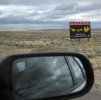
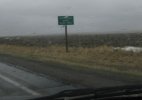
Signs we don't have back home
--Click to Enlarge--
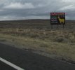
A different kind of speed warning
--Click to Enlarge--
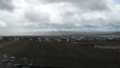
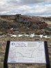
We pulled over to see what this was about. I was interested in the view on the horizon.
--Click to Enlarge--
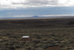
Pilot Butte (visible on the middle of the horizon in this wide angle shot) and the graves of the unknown emigrants.
--Click to Enlarge--
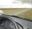
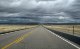
The roads out here are pretty straight, but those clouds portend interesting driving, ahead.
--Click to Enlarge--
Silly camera focused on the raindrops as we crossed the Continental Divide in the barely liquid rain at 7550 feet.
--Click to Enlarge--
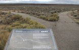
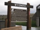
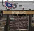
South Pass, WY. Read all about it.
--Click to Enlarge--
We saw on the map that there was an Atlantic City near our planned route. So we decided to go see what it was about. It was about 45 minutes down a mud road. We stopped here for a while so I (and my time lapse camera) could watch the weather crossing the valley. Left the camera running for the winding road to town.
--Click to Enlarge--
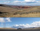
Here's the valley in question. A veritable essay in visual textures.
--Click to Enlarge--
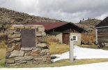
We continued forward on the dirt road till it looped back to the paved highway, and backtracked up the slope to the divide and into another dirt road over to South Pass City. It was a shorter off road jaunt than Atlantic City. This town is laid out and set up for tourists, a true roadside preserved gold mining ghost town with some still-active mines. But it, too, was closed for the season. However, the owner of the gift shop and gatekeeper of the first Mason lodge in Wyoming was as voluble as promised. She and I chattered for quite a while, till Karen gave up and walked over to the old town. I joined her and took some snapshots. We were a bit too late this season at several sites. Northern treks should be limited to the May-September tourist season.
Arriving at Atlantic City. It is a mite different that the one out east.
--Click to Enlarge--
Although there is still some mining going on (gold, iron, etc) this 1880's mining town is also a museum unto itself. Ready for the run of summer tourists.
--Click to Enlarge--
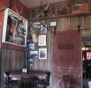
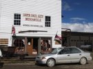
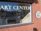
A shot inside the trading post. Every wall is a museum of different facets of the mining, hunting, settler life.
--Click to Enlarge--
A rainy off season day in downtown Atlantic City
--Click to Enlarge--
Read the sign to see how the town survived.
--Click to Enlarge--
While Atlantic City is on the east side of the divide, sister city South Pass is on the west. Read about our stop there in the daily text.
--Click to Enlarge--
Our little car was a little muddy before this jaunt. Now it is a paler shade of dingy.
--Click to Enlarge--
As I mentioned, there have been working mines here on and off for a century and a quarter. Gold, Uranium, what-have-you.
--Click to Enlarge--
So onward up WY-28 to US-287 to Lander. Lander? Yes the same place we'd stopped for cappuccino on our way out. The Old Town Coffee House was in between grinders, so we had to settle for Mellita filtered steamed milk cafe au lait. It was we-eak. But we looked at maps and decided to head on through Riverton and stopin Shoshoni. My Droid siad there is one motel in town, and it was fairly nice. Driving through Riverton proved to us that it was no place to stop. Yes, it was cheaper, and yes it had cappuccino, but it was a gambling, smoking, drinking capitol of the Wind River Indian Reservation. We wanted a quiet room.
I saw some evocative red landscape, and stopped to look around. Karen stayed in the car.
--Click to Enlarge--
My shadow, my reflection, and the is not an eff chopped off on this sign in Lander
--Click to Enlarge--
I was annoyed to see that we must be on a same road that we took in 2001, when we headed to Lander \(/Sep2001/journal.htm#s24\). I like to try different routes.
--Click to Enlarge--
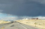
I like interesting skies, even if it might mean troublesome driving.
--Click to Enlarge--
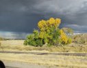
A study in contrasts, brought to you by high prairie weather.
--Click to Enlarge--
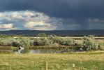
Zooming along with Karen driving, I took many pictures of light and shadow and the interplay of colors. But here is a pond.
--Click to Enlarge--
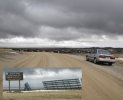
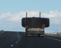
We followed this truck quite a ways. You know you are in mining country when a spare tire is a wide load, and a tractor-trailer can only carry four at a time.
--Click to Enlarge--
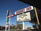
So we called ahead and got a room at Shoshoni's Desert Inn. An old roadside motel run by a very friendly hunter, After checking in, we found that their wifi was good, but the internet connection uselessly unreliable. The manager was so friendly about it that it didn't really bother me. This town has 645 residents and is only 4820 feet above sea level, our lowest town in many days. But the sun was setting, and I went out to see if there was any scenery to see. I took sunset pics out in a cactus laced field and the wind grew strong. I chased my hat a few times, and retrieved it from cacti. But after a snack, I was done in, so turned that way.
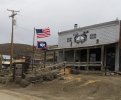
So we arrived at the Desert Inn in Shoshone, a surviving remnant of the road boom of the 1950's and '60's.
--Click to Enlarge--
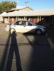
Another shot of my shadow spanning the parking lot toward Karen at our car and room.
--Click to Enlarge--
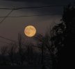
After unpacking, I wandered around and snapped some shots of the fading light in Shoshone, Wyoming. The moon was particularly impressive that night.
--Click to Enlarge--
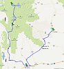
Map of three days, from Old Faithful to Jackson to Little America and up to Shoshone via Atlantic City and South Pass City.
--Click to Enlarge--
After 3 days of travel, we are now about 4 hours from Old Faithful, via direct route. As I have come to say, the trip is the destination. But now we proceed downhill, planning to take US-20 across Nebraska. Well, we expect to get into Nebraska, today.