09/15/01: Saturday Sep 15, '01
We packed up and were on our way by 9. Four days on the road together, and we weren't getting along. We thought that Karen had left our AAA South Dakota tour book behind, which was annoying. I must have been snippy, since Karen kept telling me how I was contradicting her. I didn't dare argue the point.
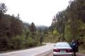
Hilltops lost in clouds as we take a break by Bridal Veil Falls in the Black Hills of South Dakota
--Click to Enlarge--
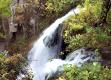
Roughlock falls harbor ferns and other rainforest-like flora
--Click to Enlarge--
Duh
--Click to Enlarge--

We drove up I-90 to Spearfish, and drove south into the Black Hills from the top. (US 14 to US 385, in brief, to the city of Custer.) In detail, we entered the cloud capped hills (named "Black" because of the dark evergreen foliage, not the dark soil and rock formations) and followed the Spearfish Creek between them for a while. We pulled off a couple of times for the scenery. One stop was labeled "Bridal Veil Falls". I estimated about a gallon a minute, but on closer examination, it probably was upwards of five. Hardly impressive at the end of this dry season. We spent some time there unwinding, and trying to get our compatibility back. I climbed the rugged, jagged scree beside the falls. Karen had a cup of yogurt at the bottom. This outdoor break seemed to help. We later got to Roughlock falls (named for the crude procedure of binding your wagon wheels to keep them from turning during the descent), which was a short detour down a dirt road. Now these were more like it. I wanted to get into the water and under the falls. But the cool, drizzly weather wasn't quite right. Never mind the frequent signs forbidding it. So we drove on.
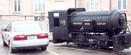
Although we got about 40 mpg, the vehicle on the right ran on compressed air for many decades down in the mines in Lead, SD
--Click to Enlarge--
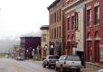
Looking down the main street of Lead, SD, you can make out the mine head (elevator shaft) like a hazy chimney on the ridge in the distance
--Click to Enlarge--
Low clouds, or high hills, make the ground wet, but those working 8400' below don't really notice
--Click to Enlarge--

We drove upward along 385. Into and back below the clouds. We reached the steep streets town of Lead (as in "Lead me to the gold"). On impulse, I stopped at the mining museum. We arrived at 12:20, so we took the 12:30 underground mine tour. Well, it was a mine mock-up in the underground basement of the museum. But the equipment was real, and the guide had been a miner. We spent 2 1/2 hours there. Cool stuff. The gold mine, active on and off since the 1880's, is to be shut down this year. It has tunneled already 8500 feet down (from just over a mile above sea level). There is more gold, but the $280/oz. is too cheap to pay for its extraction.
A couple came into the museum a few minutes after the last tour had departed. They were disgruntled. They had been to see Mount Rushmore, but the clouds never lifted enough for them to see the faces. It just wasn't their day.
After Lead, we headed on South toward Custer, where we planned to spend the night. My sinuses protested the steep climbs and dips of the road. Coffee and decongestants helped. We passed a rock shop at the side of the road at 5:00. The sign said closed, but Karen was driving, and she spotted someone getting into an SUV on the side of it. She pulled over, addressed them, and they agreed to open the shop again. We shopped their bins, and bought a few regional rocks. The Black Hills have a cool range of geologies, all exposed to the surface. I am partial to an ingneous or metamorphic matrix with white veins of volcanic quartz running arcross the original strata.
Our first view of Black Hills sculpture projects, just North of the town of Custer
--Click to Enlarge--
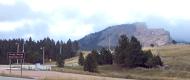 Finally, on toward Custer. As we approached the Crazy Horse Memorial, the low and heavy gray skies parted briefly. A spot of blue showed. We continued after a quick snapshot.
Custer, SD, elev. 5300 ft. I pulled into the Bavarian Inn on impulse to check prices. It was on the northern outskirts of Custer. After checking a few other places, we returned and checked in. Karen was happy with this apparently absurd choice. We ate rouladen and rot-kohl dinner in their restaurant, too.