10/22/04: Hovenweep: Off the too-badly-beaten path
I wrote this in Towaoc.
Towaoc? Try Ute Mountain or Sleeping Ute, Colorado. On the reservation along U.S. 160, "11 Lucky Miles South of Cortez" there is a casino. We see Ute Mountain from our room.
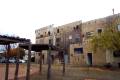
A mural on the back of the Cortez, CO Heritage Center
--Click to Enlarge--
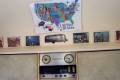
Inside the Silver Bean coffee trailer, some family memoribilia
--Click to Enlarge--
The menu in the Silver Bean, and the lovely curtains!
--Click to Enlarge--

Before leaving Cortez, we stopped for a cappuccino at the Silver Bean
--Click to Enlarge--

Why, you may ask, are we still so close to yesterday's place of repose? Well, after we "did" the Cortez Heritage Center, and had a cappuccino in the "Silver Bean" a 1960's Air-stream trailer, we drove out to Hovenweep National Monument.
It's about 40 miles from Cortez via Airport Road.
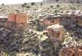
More ruins from the late 13th century. But a nice valley and quite an impressive set of buildings for such a short occupation. It was cloudy and cool, but the sleet that started the day stopped as we arrived up there. We even saw a patch of sun, once.
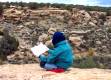
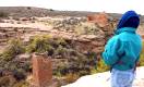
Hovenweep National Monument barely in Utah. Karen pauses at the precipice to consult a map. See some of the ruins across the vally (right above her back)
--Click to Enlarge--
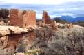
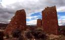
Some of the 2 story buildings that were part of the Hovenweep city. Note the cloud piercing mountain?
--Click to Enlarge--
I never could pass up a dramatic lighting shot. Drizzly and cold days are good to me.
--Click to Enlarge--

Looking down into the 3 story, um, granary? Note the retaining walls at its base.
--Click to Enlarge--

See the way the tower twists. This is structurally stronger, but was it intentional?
--Click to Enlarge--
Now, this is a relatively new development. The old Ranger's shed has been replaced by a new interpretive center. They even have a paved path up to the near end of the canyon. From there, they laid out rocks to mark the trail all the way around the rim. No guard rails. No fancy signage. Just some thin chains around the actual structures to indicate the keep-out-ness of them. I like it.
Bleak adobe ruins at Hovenweep. Drizzly day end is in sight.
--Click to Enlarge--
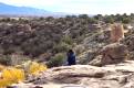
Dan's legs dangle as he looks out over the Hovenweep valley. Colorful cottonwood trees below, and "eroded boulder house" and a "D" tower to his right (and a half mile away).
--Click to Enlarge--
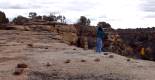
In Hovenweep Nat'l Monument, a line of rocks takes the place of hand rails, guard rails, and trail markers. Watch that next step!
--Click to Enlarge--
Last shot of Hovenweep, really. Looking into the "eroded boulder house" and the twin towers of 400 years ago.
--Click to Enlarge--
On the way back, we stopped and glanced into the Canyon of the Ancients, and stopped at a winery. By then, we could barely have made Shiprock by sunset, and certainly not on to Farmington, NM before dark. So, we stopped and got a fancy, new room in an Indian casino. I ate too much fry-bread taco, but Karen saved leftovers from her chipotle-BBQ ribs. On a Friday night, the place was packed with locals of non-European extraction.
We didn't have time to explore the Canyons of the Ancients, but we stopped at the gateway.
--Click to Enlarge--

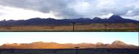
Evening and morning views of Sleeping Ute mountain from our motel room on the res just south of Cortez, CO.
--Click to Enlarge--
Do yall remember our original plan to head down to Albuquerque, tour Sandia, and on down to Carlsbad Caverns near the Texas/New Mexico/Mexico border?
Well, we spent too much time "up" in Colorado. Tomorrow, we plan to finally get into the top of New Mexico (Hillerman country), and then basically to take U.S. 64 back over the mountains, along the Oklahoma pan handle (the only "pan handle" in the U.S. that actually looks like a pan handle), and up 66 to Missouri.
We will skip visiting the actual "Four Corners" monument; the only place in the U.S. where 4 states meet. It costs more than we think it's worth to see this cartographers curiosity.
At least the best laid plans do get laid { :-})>
Gang aglee, indeed.