10/25/04: Raton, NM to Alva, OK?
We start the day with hearty blintzes at the Sands Restaurant, next to the Best Western in Raton, NM on the Santa Fe trail.
As I moseyed out of breakfast this morning, I shot my shadow. Here it lays in the parking lot, surrounded by the porch of the Sands Restaurant, next to the Best Western in Raton, NM.
--Click to Enlarge--

We get on the road by 9:30, and drive up scenic, winding State Road 72 past Sugarite Canyon (we don't stop) and Folsom (which is closed, the whole town!). Along the road, I'd noticed what was apparently a neglected Point of Interest pull-out. I later found out that that was the place where the first Folsom man artifacts and other evidence was found. The Folsom find was the first clue that people had lived in the Americas for at least 10,000 years, since the Bering land bridge formed. (More Folsom Info)
The state road was more interesting than the U.S. highway. Here's a look at the mountains from atop a large mesa.
--Click to Enlarge--
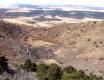
Anyway, we did spend time on and in the Capulin volcano. It was a 100' vertical hike down to the vent plug in the center, and then a 410' hike up to the peak of the rim up at 8,182' above sea level. The rim is about 1,400 feet in diameter, and of course we hiked all around it. This is the youngest in the series of volcanoes one can see all over this part of New Mexico and on down into Mexico, about 50,000 years since its last eruption.
Karen climbs up the path to the peak of the volcano. This was a steep path!
--Click to Enlarge--

Looking down from the lesser of the 2 peaks on the rim, one can see the core plug at the end of the path down from the parking lot. Here we are about 350 feet above the crater floor.
--Click to Enlarge--
After this, we knew that we had to get some miles on. We bade the mountains good-bye, and got back down to U.S. 64 (the Santa Fe Trail) and drove East (ish).
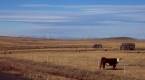
Welcome to the Oklahoma pan handle. Most of the views are like this.
--Click to Enlarge--

But, even here I find the interplay of light in the clear glass insulators on those power poles interesting.
--Click to Enlarge--

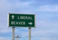
Choices, choices. Why does this sign make me think of Bill Clinton?
--Click to Enlarge--
Now, these highway numbers seem eerily familiar. But I'm sure this is Oklahoma. (In StL, I-64 crosses I-270)Notice the shadowy dude in a hat? I thought I'd shot him this morning.
--Click to Enlarge--

We stopped at 7:30 in Alva, OK. We're almost halfway across Oklahoma! We only have to drive for about 9:40 hours tomorrow (according to AAA.com and Mapquest).
We're staying in an older motel under new Pakistani management with the sign out front spelling out
Ranger Inn
Jesus is Lord
Recently Remodeled
Wireless Internet
It's an inexpensive, yet nice place with fridge and microwave in the rooms.