09/30/10: Day 7: Over the Cascades into Seattle
I woke before dawn, dressed, and slipped out to walk along the river and across town to see the Grand Coulee Dam at sunrise.
I was up before sunrise, and walked around the dam town. Looking up, I spied an eagles nest. I think.
--Click to Enlarge--

The bridge across the Columbia River in Grand Coulee is a nice 1930's steel truss structure. It is designed for walking as well as traffic. Can you see the sign boards angling out from the guard rails?
--Click to Enlarge--

Pedestrians can walk either side of the bridge. Upstream here, facing the dam, are pictures and stories from the days of construction. On the downstream side, the saga of volcanoes, tectonics, the glacial lake, and erosion that created this basalt crevasse that contains the second largest river on the continent.
--Click to Enlarge--

The rising sun paints the hills overlooking Grand Coulee Dam and I head back to the motel.
--Click to Enlarge--
You may or may not have noticed these little bronze markers on buildings, sidewalks, or in concrete monoliths in the countryside. These are the benchmarks that let surveyors know where they are. Their locations are accurate to around a part per billion in latitude, longitude, and altitude. This one, in particular, seems to be set through the sidewalk by the bridge (probably anchored to bedrock below) to let surveyors easily check the settling of the dam.
--Click to Enlarge--

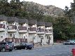
As I returned from my walk around a quarter past seven (PDT), Karen happened to have just gotten up and stepped outside to see if she could see where I'd gone. See our sad car by the nice motel.
--Click to Enlarge--
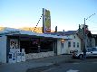
Karen was waiting for me when I got back. We packed up, checked out, and headed across the bridge for breakfast.
We'd asked locals for suggestions on where to break fast. So the R&A Cafe it was.
--Click to Enlarge--
Again, I stepped out to catch the light after we'd ordered.
--Click to Enlarge--
Public art, depicting an evening's recreation of a worker's family during the dam construction. See the glow of the arches supporting the road over the dam.
--Click to Enlarge--
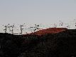
The Grand Coulee Dam was built with irrigation in mind. Those pipes at the top irrigate thousands of hectares in the Okanogen Valley that we'll be passed through. The original plan for the electricity was primarily to pump water. Now, of course, it helps light Los Angeles. Yes, all the way from Washington State.
--Click to Enlarge--
Then we drove uphill and downstream along State roads 174 and 17.
So we drive on out of the Columbia Valley from Grand Coulee, glancing back to see the insulators glowing in the morning sun.
--Click to Enlarge--
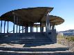
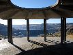
This modern sculpture was designed as a tourist overlook for the dam area. Unfortunately, the site is not as much a draw as it once was. This cool shelter is not well maintained.
--Click to Enlarge--
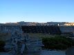
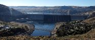
The Grand Coulee Dam seen from the scenic overlook
--Click to Enlarge--
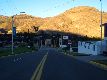
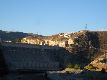
The two towns and the nice bridge between
--Click to Enlarge--
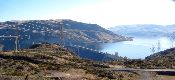
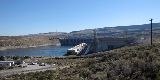
We reconnected with the Columbia River at another dam site. Chief Joseph Dam is the second largest hydroelectric facility in the U.S. Then we crossed the Okanogan Valley, home of the Washington Apple.
No. This is not another picture of the Grand Coulee Dam. This is the Chief Joseph Dam \(http://en.wikipedia.org/wiki/Chief_Joseph_Dam\) a ways downstream. This smaller dam is actually the second largest producer of hydroelectric power in the U.S.
--Click to Enlarge--
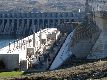
The Chief Joseph Dam does not store water in a large lake as do Grand Coulee or Hoover. It passes the full flow of the Columbia River through its many turbines to produce electricity. If the flow exceeds what the turbines can handle, they just let the excess river flow through the floodgates.
--Click to Enlarge--
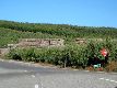
Ever wonder where all those Washington apples come from? Here's where they are picked and packed, the Okanogen Valley.
--Click to Enlarge--
So we stopped for fresh apples, and ended up with coffee and scones.
--Click to Enlarge--
Karen loves the smell of unwaxed, fresh-picked apples.
--Click to Enlarge--

Advised by one of my readers, we took the half-day-longer northern Cascades route through the town of Winthrop instead of the more direct Southern Cascades loop.
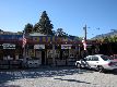
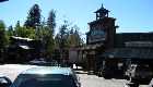
So we stopped in Winthrop. Basically a town built as a shopping nexus for the gold rush, and reinvented as a gold-rush-town-themed shopping nexus for the tourist trade. There are local art shops, and stores rivaling Wall Drug or Clines Corner in tourist knick knacks. The buildings are actually concrete and pressure treated wood, in Olde Timey styles.
--Click to Enlarge--
As I said, it always was a town designed to separate marks from dollars.
--Click to Enlarge--
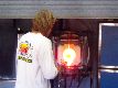
The one thing I liked in Winthrop was the open art studios. Passers-by are protected from flying shards by a screen, but otherwise, the artist thrusts his rod in and out of the glory hole right in front of you.
--Click to Enlarge--
We'd seen many authentic old towns, so this plastic imitation did not impress us. I do have to admit that it is still true to its original charter: Separating travelers from cash.
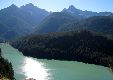
But the Cascades drive was quite nice, if a bit exhausting. Especially since we expected to dance this evening.
Our first sight of snow on the mountain. This late in the season, that ice must be the remains of a glacier.
--Click to Enlarge--
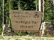
Because of the Winthrop detour, we took the northern path over the Cascades.
--Click to Enlarge--
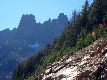
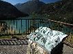
The view from the overlook at the pass in the Cascades. Deep green lake, and patches of glaciers in the mountains
--Click to Enlarge--
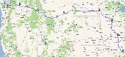
They had this helpful verdigris bronze map to show us where we are.
--Click to Enlarge--
Why do tunnels and bridges fascinate me so?
--Click to Enlarge--

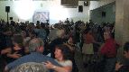
We made it in to Seattle this Thursday evening through rush hour, in time to stop in with our hosts and run out for a light meal, and on to the contradance. Because of a very recent and high profile death in the community (Warren Argo), it had become a major reunion and memorial event. The large hall was packed with the best dancers, and dozens of musicians came to play.
The Thursday night contra dance in Seattle was partly a wake this week. See the trip text. A big crowd, and an odd program of dances. The tall redhead in the back is Marianne Tatom-Letts calling this one that I sat out to snap shots.
--Click to Enlarge--

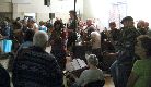
I usually shoot dances without a flash or tripod; it better shows the motion. Tonight I was also sternly ordered not to use a flash because one of the locals is prone to siezures. Not bad for hand-held in a dark room.
--Click to Enlarge--
Because of the memorial nature of the dance, every musician in town wanted to play. It was as impressive as the St. Louis Folk School \(http://www.folk-school.com/\)'s "Wall of Sound" band.
--Click to Enlarge--
Seven days, seven stays, and we've passed our far north point and head south. But first, a couple of days in Seattle.
--Click to Enlarge--
We have now passed our far northern part of the trip, and Seattle is about as far west as we are going. We'll spend 2 days here, and then start heading south.