10/12/11: Day 13: Shoshoni, WY to Gordon, NE
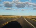
Day 13: National Fossil Day, 2011. I woke in Shoshone, WY before sunrise, as usual. I dressed and slipped out with both my super-zoom and pocket cameras, retrieved the tripod from the trunk. The car had a protective layer of frozen dew over the mud we'd picked up in the rainy old gold mining towns yesterday, so I didn't add any more dirt to my jeans. I crossed the highway and set up a time-lapse of the rush hour traffic and sun rise. I'd tried a time lapse sunrise last year in Battle Mountain, but still haven't done anything with it. One issue was that the color was better away from the sun than into it. So this year, I set it up looking west toward the mesa and down the highway. Anyway, I then took my other camera and was out standing in the field snapping shots for an hour and a quarter while the smaller mounted camera watched the moon drift and the light change. I woke Karen up when I came back in near 8:00. We got on the road about 9:30.
I got up early and took pictures (and time lapse) on the outskirts of Shoshoni as the sun rose. (If you are just looking through the pictures, this one starts another day with some elaborate text description not in the captions).
--Click to Enlarge--
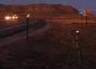
Looking back down the road toward the snow capped mountains in the west as dawn breaks.
--Click to Enlarge--

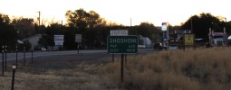
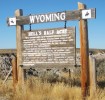
Welcome to once thriving Shoshoni, WY
--Click to Enlarge--
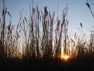
The view of a snake in the grass at sunrise
--Click to Enlarge--
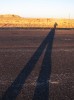
Another good one for my Album of shadows, A Void in the Landscape \(http://www.facebook.com/media/set/?set=a.3290928567140.108006.1685526085&type=3\). This one has my head to the moon.
--Click to Enlarge--
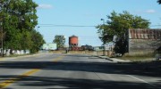
Shoshone is one of many dying towns on US-20. Like classic Route-66 it had a boom time from the post war years, building on the traveling family tourist trade until around 1970, when the interstate system really got going. Another factor is that people don't travel much any more. Most still fly over America to see specific sites, and miss most of what there is to see. Others stick to the interstates, and only stop at built-up tourist sites with the notable feature within shouting distance of a parking area.
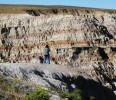
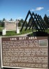
Anyway, we headed east on Highway 20, sadly watching the snow capped mountains sinking slowly behind us. Then Karen saw one of those tiny "Scenic View" signs as we whizzed along at 70 mph, and mentioned it. I said, "sure." We braked and made the sharp turn to see a barely-visible-fron-the-road wooden Wyoming information sign and a six foot tall chain link and barbed wire enclosure. "Hell's Half Acre." The sign explained in detail how this was a historic buffalo killing ground. We drove into the chain link pen, and there was a view that could easily be mistaken for Bryce Canyon in miniature. But the chain link made it hard to appreciate the view. Also, the fence was clearly a few feet inside of where old railing had been. Pieces of concrete walkway, and even a small building pad, were visible in the weedy enclosure. There were a few scuttle-under holes around the fence, but with the recent moisture, I didn't feel like scuttling in the dirt. Since the solution was not to be found inside the box, we went outside, and found a nice hole in the standard barbed-wire fence back toward the highway with a well worn path to the edge. Now, the fence kept us from getting too far from the edge, instead of too far from the view. It was very nice. As we walked the other side of "the wire", a tall, dark, and charming gent (of a non-melanin-deficient race) chatted with us about the inequity of the view. We pointed to the hole we used, and he said that he'd join us. But his dog was too excited, and he only came to the edge and then back inside with the his darker companion. Just for my own recollection, he was Walter from sno-life.com, a company dedicated to promoting extreme snow life, as in boarding in Jackson Hole (his current destination).
A scenic spot that one can easily overlook, so easy to blow past and not even notice. Once it had tourist conveniences. Now, you have to step over barbed wire to see it.
--Click to Enlarge--
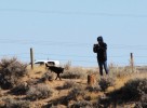
Dan on the brink taking pix. There's also a cool one of Karen that only shows in the text of the day. An anigif for depth.
--Click to Enlarge--
A man and his dog. We chatted here with Walter from sno-life.com \(http://sno-life.com\), a company dedicated to promoting extreme snow life, as in boarding in Jackson Hole (his current destination).
--Click to Enlarge--
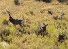
We saw little wild life on this trip, so I used my long lens to snap some deer here in the bottom of Hells Canyon.
--Click to Enlarge--
So after about 45 minutes, we decided to move on. I snapped pictures from the moving car and Karen drove. My 8GB chip filled up, so we stopped at a truck parking area along the road for me to dig out another chip. It was very windy. I'd had no coffee, so I looked up "coffee houses" on the Droid map app. The nearest was in Casper. Just an hour and a half away.
The first "coffee house" was Riverside Cafe, a lunch cafe with no coffee. The next was Hot Shot Java, that turned out to be a kiosk. We tried a bakery, that turned out to be open by appointment only. Then we asked at an antique store, who directed us a few blocks away to a book store for a $5 latte. We got out of town.
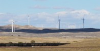
We stopped briefly to admire a wind farm in partial cloud shadow. There is so much steady wind up here, I had been wondering that there were not more of there. In fact, the wind farm is right by an old fashioned power plant just east of Glenrock (site of a rock graffitied by early settlers). We stopped there because my Droid map showed a nice way to avoid the interstate from Glen Rock to Douglas, but Tank Farm Road turned out to be a rough gravel loop of 10 miles. Not worth the effort, so we took a few miles of I-25, going 5 mph faster than the state and federal highways allow to Douglas, WY. From then on, there was much pastoral scenery, hills, fresh round bales and stacks of square bales of hay, a few buttes, and pretty clouds. But so many towns that haven't yet given up, but mostly boarded up.
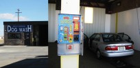
After these several days of dry back roads, our car needed a wash. The apparently veterinary name of this place brought us in.
--Click to Enlarge--
We stopped to look at a power plant. But, what's this on the horizon? Those aren't all high tension towers...
--Click to Enlarge--
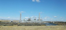
The power plant is augmented by a wind farm. Note the coal train in the foreground, too.
--Click to Enlarge--
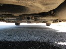
My camera chip got full as I snapped pix, so I popped it out to change it. Then crawled under the car to find where the wind had decided it belonged.
--Click to Enlarge--
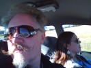
Just a reminder of who is traveling how.
--Click to Enlarge--
From Casper to the NE-29 (labeled as the Agate Fossil Bed turn-off) we were retracing our outbound trip. But on a partly sunny day it looked quite different. Especially the big, oak water tank in Lusk, WY that rates the National Register. Anyway, we considered stopping in several towns, but the light was nice, and both the Droid and AAA said there was lodging in Gordon, a dozen miles from the South Dakota border.
Why does "Lusk" sound so familiar?
--Click to Enlarge--
Oh, yeah. We passed through Lusk on Day 4 \(travel.cgi?Date=20111003&Trip=2011OctTrip\).
--Click to Enlarge--
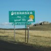
Welcome to Nebraska?
--Click to Enlarge--
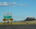
Scenic Nebraska
--Click to Enlarge--
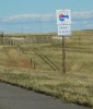
Still not heading to ScottsBluff.
--Click to Enlarge--
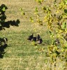
Do turkeys count as wildlife?
--Click to Enlarge--
Legend Buttes, NE? It is pretty pretty, on the edge of Fort Robinson State Park. But facilities are closed for the season.
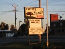
So we spent the night in a cabin behind the Western Sands Motel, another struggling mom-and-pop place with old rooms and iffy internet. But friendly, clean, good beds, etc. And we ate across the highway at the Antelope Creek Cafe. I like these smaller towns. The grain elevator (main industry) is a half block from the motel.
Heading steady East in the late afternoon in Nebraska
--Click to Enlarge--
We stopped for the night at the Western Sands Motel in Gordon, NE.
--Click to Enlarge--
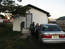
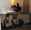
The Western Sands had old style strip motel rooms, or cabins. We opted for a cabin. I don't know what Karen was saying here, but I wouldn't doubt, "Are you taking even more pictures?"
--Click to Enlarge--
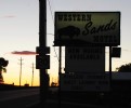
Another shot of the Motel sign, with a touch of sunset and road sign for ambiance. I took this as we walked the couple of blocks to the restaurant at the other side of town.
--Click to Enlarge--
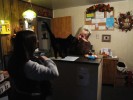
The Western Sands concierge keeps tabs on us transient types.
--Click to Enlarge--
This is actually a shot of me writing up the day in the evening, and Karen checking email the next morning. The cabin was pretty nice.
--Click to Enlarge--
Here's the Google map of the day.
View Larger Map