09/27/10: Day 4: Across North Dakota and into Montana
Most of the day is in the captions. I was driven to get across North Dakota and into Montana to meet our schedule. We relative southerners are surprised to see that the tremendous majority of interstate exits have "No Services".
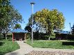
First thing on the road from Fargo was supplies. This looked like a likely grocery store.
--Click to Enlarge--
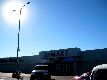
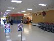
But it was really a mall! Up here in North Dakota, it is cold so much of the year that it makes sense for most stores to consolidate. I looked around the hardware store and video arcade while Karen did the actual shopping.
--Click to Enlarge--
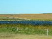
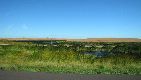
The water up in ND this autumn seems ridiculously blue. It also appears to be deeper than the planers expected. Note that it is halfway up the power pole!
--Click to Enlarge--
Signs of age: I need polarized sunglasses to read the road signs and see the sights. I also need reading glasses to see the map in my lap.
--Click to Enlarge--

The rest areas up in the northern great plains have sheltered picnic tables. Not just from above, but always on 3 sides, too.
--Click to Enlarge--
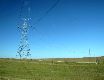
I am easy to amuse. There are hundreds of designs for high tension power poles, and I idly plan to spend a year (eventually) sketching all that I find. Meanwhile, I notice the sun is so sharp that one can see the shadows of the power lines in the grass.Note: As with most pictures of the roadside, this was shot from the moving car (at 1¼ miles a minute), so the foreground is blurred, and there are reflections in the glass.
--Click to Enlarge--
Looks like a lonely job, mowing the roadside up on the plains.
--Click to Enlarge--

The low sun, the wind in the grass, and the unreal water created some truly unbelievably colored landscapes. This is really how it looks up there.
--Click to Enlarge--
Faint though the moon above the power tower,last year's hay slumps,before fields of sunflowers
--Click to Enlarge--

What's up with Dan, these power towers, and the moon? Can it be an unfortunate side effect of an Electrical Engineering degree and a minor in Fine Arts?
--Click to Enlarge--
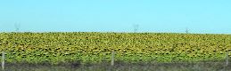
Maybe I should have stopped to take a picture of these endless fields of sunflowers at their peak of ripeness. But surreality is fun, too.
--Click to Enlarge--
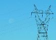
Sentinels stand across the land holding live wires in every hand. What the hay? Sense of scale: Those bales are big enough to crush a man, tiny against the delicate tracery of the grid.
--Click to Enlarge--

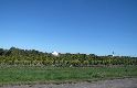
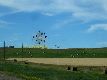
Vineyard, orchard, woods, house, barn, water windmill. Just an agrarian scene.
--Click to Enlarge--
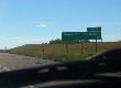
We saw a sign in passing saying "Continental Divide" a third of the way across North Dakota. "What!?" I wondered. I asked the elderly greeter at the State Museum in Bismarck. It turns out that we'd passed its complement without fanfare in Minnesota, entering the Hudson Bay watershed, and then exiting it again in North Dakota. Yes, we were on the downhill side of the continent toward the North Pole for a few hundred miles without knowing it!
--Click to Enlarge--
 We crossed the Continental Divide 5 times in this trip. This was # 2,but the first we noticed.
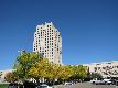
This box is the State Capitol of North Dakota in Bismarck. The original burned down, and they opted for modernism to replace it.
--Click to Enlarge--
Keeping Our Heritage Safe for the Future. Nice tag line.
--Click to Enlarge--

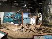
What is a state museum without dinosaurs. This one (Bismarck, ND) has some of the best samples from the area. Here, they have even found skin large areas of imprints. They remind me of the ostrich skin purse my mother had. Now we know why: Many later dinosaurs had feathers!
--Click to Enlarge--
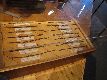
I've been to a few barbed-wire museums over the years. This display in the North Dakota State Museum is a small (but representative) subset of the technology that made it possible to open the west to grazing.
--Click to Enlarge--
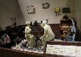
What would a State Museum be without a nod to Victorian optometry?
--Click to Enlarge--
And what sort of building did North Dakota choose to keep antiquities from between 20 and 120,000 years ago? A glass box. Self portrait at the entrance to the museum.
--Click to Enlarge--
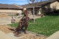
Big cow standing on a hill overlooking another field of sunflowers. A local artist here made quite a few monument scale pieces.
--Click to Enlarge--
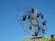
"Flying Geese" is pretty big. Look at the 6 foot rolls of hay, or the RV to get an idea of how big this sculpture is.I appreciate public art, especially on a grand scale.
--Click to Enlarge--
Another shot in passing from back on I-94. That thing is BIG.
--Click to Enlarge--
The Dakota Dinosaur Museum \(http://www.dakotadino.com/\) in Dickinson, ND was already closed for the season.
--Click to Enlarge--
Aargh! A rock shot up from the road, right toward my face. Fortunately, the windshield stopped it. But I fear this was a fatal blow for the glass. Those spider cracks are not worth stopping, given the price. We'll just have to buy a new windshield when they spread. This one has enough wear and tear to make replacing it the better option, anyway.
--Click to Enlarge--
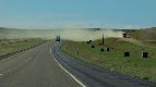
Most side roads up here are not yet paved. I liked the sight of these long, straight, dirt roads running to the horizon.
--Click to Enlarge--

As I said, most roads aren't;y paved. Cough.
--Click to Enlarge--
Warning: Unstable Area. Unlike the dryer and rocky Badlands farther south, the grassy edged canyons of Theodore Roosevelt National Park have dangerous, crumbly edges.
--Click to Enlarge--
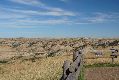
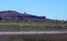
Unfortunately, we were having a bout of uncongeniality, so we didn't enjoy this stop as much as we might have. But it is as impressive as the geologically similar but separate Badlands of South Dakota.
--Click to Enlarge--
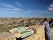
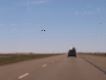
While we were at Theodore Roosevelt Nat'l Park, a helicopter was doing something down there. Apparently following stream beds. Maybe spraying for invasive species?
--Click to Enlarge--

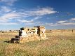
The entry marker for Theodore Roosevelt National Park \(http://www.nps.gov/thro/\). He's the guy who set up this parks system, as separate from the National Forests that are run by and for the extraction industries.
--Click to Enlarge--
Almost to Montana. Have yet to see deer or antelope play.
--Click to Enlarge--
There it is. Montana, the widest state we have to cross.
--Click to Enlarge--

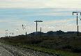
Gleaming filaments festoon along the road. One cannot capture the depth and brilliance of the glowing light in a photograph. But I try.
--Click to Enlarge--
We call it quits in Forsyth, Montana, just 509 miles from Fargo. The Rails Inn sits cozily between the interstate (I-94) and a rail yard, on old US-10, locally known as Front Street.
--Click to Enlarge--

We pop over to a local eatery. Karen is hoping to find berry pie. They didn't have it. But we ate well.But, the Howdy Motel?
--Click to Enlarge--

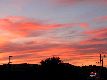
While waiting for our food, I stepped out to take a few snapshots of the sky. We are now in Big Sky Country. Probably a better show than whatever is at the Roxy.
--Click to Enlarge--
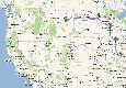
Just glance at the trip so far, thanks to Google Maps \(http://maps.google.com/maps?f=d&source=s_d&saddr=63104&daddr=Cedar+Rapids,+IA+to:Minneapolis,+MN+to:fargo,+ND+to:forsyth,+MT&geocode=FQM8TQIdAFuf-imxEuxdd7PYhzEO46vQ2MpCgQ%3BFQVMgAIduuSI-ilRQi-gel_khzHA3eYsQ2DuVQ%3BFf1WrgIdJOhw-im9u3eTkDOzUjEH7novhMmfkw%3BFQJKywId1Ro7-ilFcWeEjcvIUjHKqpEnpTCqgQ%3BFRD4wQIdzDmk-Smbko78AuE5UzEKHPeX26nb9w&hl=en&mra=ls&sll=42.940339,-95.405273&sspn=12.928794,28.54248&ie=UTF8&ll=42.90816,-118.87207&spn=21.80293,19.379883&z=5\).
--Click to Enlarge--