10/04/10: Day 11: Vancouver, WA to Eugene, OR by a scenic route
Most of the day is told in the picture captions. Basically, we drove the Mount Hood Scenic Byway almost a full circle, then south.
After the frustrating rainier day of trying to see Mt Rainier, we had stopped outside of Vancouver, Washington at a Days Inn tucked wa-ay behind the Westfield mall. Karen went to the pool and hot tub (that wasn't hot enough) while I wrote up the day. By 7:30, we were ready to wander out to find some food. We figured that a mall would have a food court. We didn't figure that the mall closed at 7! But Sears was atypically open late for a special promotion. I thought that I'd stop in for a replacement travel mouse. As I found that, Karen found a clearance backpack to replace our disintegrating one. Then we found an American Tourister roll-along suitcase at better than half-off to replace the embarrassingly well worn mid-90's one that Karen's been using on these trips. Plus the special event discounts, and $15 off for getting a new Sears card.So we rolled the new luggage back to the hotel and called it a day.
--Click to Enlarge--

So we hit the road around 9, and almost made it to Oregon when a forgotten item was discovered, and back to the hotel.So we hit the road at 9:25 and quickly entered Oregon.
--Click to Enlarge--

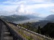
We drove along the Columbia River Gorge National Scenic Area following the Mount Hood Scenic Byway (US-30 to US-35).This is one of the first viewpoints, constructed at the dawn of automobile tourism, Crown Point State Park
--Click to Enlarge--
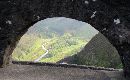
Another view from the viewpoint
--Click to Enlarge--
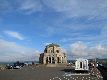
This Deco marble and granite edifice is the crown on the viewpoint.
--Click to Enlarge--
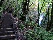
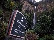
Of the many falls we saw along this scenic byway, this one was the longest walk: Bridal Veil. That's Karen up at the overlook.
--Click to Enlarge--
And Bridal Veil Falls from the platform. You really have to be there, in the fern forest, and feeling the rumble of the thundering water to appreciate this view.
--Click to Enlarge--

Karen loved the forest of ferns.
--Click to Enlarge--

2/3 mile is the lateral distance. It also takes you quite a ways down and back up.
--Click to Enlarge--

Multinomah Falls is the most tourist friendly stop. You can see it from your car. You can stop and shop, and dine, and even stay.
--Click to Enlarge--
Multinomah falls: This is the most common shot you'll find in Google images of this site.
--Click to Enlarge--

Karen sitting by Horsetail Falls
--Click to Enlarge--

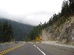
I liked the various vintage railings of stone or depression-era concrete. A very artful byway, this US-30
--Click to Enlarge--

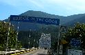
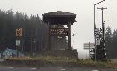
Washington? What? Yep, we went to see the "you must see" Bridge of the Gods, paid a toll, and basically found ourselves back in Washington State. Not much to see there, either.
--Click to Enlarge--

So we returned to Oregon and paid another toll.
--Click to Enlarge--
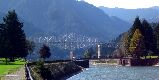
Here is a view of The Bridge of the Gods. Personally, I don't see it. Just a perfectly cromulent bridge over a major river.
--Click to Enlarge--
When we finally approached Mount Hood National Park, we caught a glimpse of the mountain. After yesterday's fiasco, it was good to actually see our target mountain. The camera in the foreground? Taking a time-lapse of the clouds, now on YouTube: Clouds crashing into Mt Hood \(http://www.youtube.com/watch?v=3LmB1_C4i34\)
--Click to Enlarge--
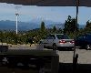
We stopped among the vinyards and orchards for a snack. Behind us, back in Washington, we could see Mount Adams \(http://en.wikipedia.org/wiki/Mount_Adams_(Washington)\). Much better viewing than yesterday.
--Click to Enlarge--
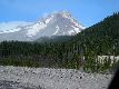
Karen snapped this shot of Mt Hood shortly before we reached Government Camp and the whole area was enclouded.
--Click to Enlarge--
Government Camp on Mt Hood. Visibility now down to yards.
--Click to Enlarge--
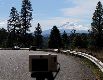
And back down the mountain to below the clouds. I find these runaway ramps both reassuring and disturbing.
--Click to Enlarge--
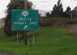
Talk about an image problem for a town
--Click to Enlarge--
Geek joke: How much are they charging those sheep?
--Click to Enlarge--

About 9 hours after we started driving, we ended up at another friend's house in Eugene, Oregon (about 3 hours south of Vancouver).
We then rested, dined well on home cooking, and got some rest.