09/05/13: Day 10: Aborting Westward, heading back down
Because of the news of serious rain & flooding in Vancouver & Seattle, we decided to head south into the U.S. and decide whether to proceed west from there, or to wend a leisurely way homeward.
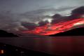
Sunrise over Okanagan Lake from the Peachland Fantasy Inn
--Click to Enlarge--
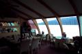
The breakfast nook at the Fantasy Inn
--Click to Enlarge--
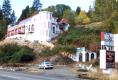
One last look at the Fantasy Inn in Peachland, BC
--Click to Enlarge--
We stopped in Penticton for wine. Karen didn’t want to leave this wine country without taking a sample with us. We picked up a few bottles of cheaper local stuff (with interesting labels) at a tour center in town. They warned us that we probably couldn’t take fresh fruit across the border. This was a major frustration for Karen each time we passed a fruit stand overflowing with varieties of local apples.
Honor system roadside organic apple sales
--Click to Enlarge--

As we passed through Oliver, BC, we were surprised with its resemblance to Southern California wine country. This area is a desert much like its counterpart a couple of thousand miles south.
So, we crossed back into the U.S. with no problems and a mere cursory examination of our trunk. We’d declared our wine, and they just wanted to make sure we only carried what we said.
Tonasket, WA: We got gas at the much lower $1.78/gal and made the decision: Head East on State Road 20. The drive was scenic, and I liked the Washington 5 car rule: If you have 5 cars behind you, no matter how fast you think you are going: It’s too slow, so pull over. It’s the law!
We stopped in Meyer's Falls, WA where the whole town was filled with smells of the Boise sawmill. We’d stopped to buy organic local apples to appease Karen’s pangs of not having bought Canadian.
After we were through Sherman Pass, at 5:56 pm we took a waterfall break. There was just a little pull-out on the road, and we walked down to see a nice waterfall and set of cascades. Karen had a supper sitting on a stump in the sun.
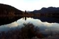
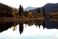
As dusk approached, the reflections on the Orielle River were quite enchanting. We stopped and I took too many pictures. Digital film is cheap.
Reflections of southern Canada
--Click to Enlarge--
Autumnal views
--Click to Enlarge--
Darkness gathered, and fog formed like cobwebs on hills dappled with autumnal hues.
We stopped for the night in Sand Point, ID and searched out the Monarch Mountain Lodge. It is in the AAA book, and is a bit out of town, hidden back behind some newer chain stores (McDonalds and the like). It had a nice family-owned feel to it, and they were in the process of updating the beds and furniture. New beds are nice. Local craftsmen make the new furniture from local trees, sawed into 1" planks and with bark edges displayed with short twigs and knots still on. This technique uses the whole tree.
The stairwell in the Monarch Mountain Lodge in Sand Point, ID
--Click to Enlarge--
The clothes hangers are formed from a single, welded loop to prevent theft. The collection of them on the rod had the effect of persistent and shrill wind chimes each time one of us passed. Amusing once. Annoying until I suggested hanging a jacket over the lot of them.
Once we were settled, we went to the nearby Golden Dragon for dinner. Recurring memo to self: Don't eat the tiny blackened peppers! (hic) I ate too much.
Discovered that I could dial in to SBC from Sand Point, so sent this email:
Well, folks. In case any of you have been wondering whether we've been caught in the floods, the washed out roads, the record deluge in Victoria and Vancouver, or the parts of Washington and British Columbia that have been powerless because of the weather: No. The two roads we had planned to take westward (BC 3 "The Crowsnest", or the Washington 20) were closed, though.
In brief, we left Maple Leaf 1 at Sicamous to head south along the 97's (97a, 97, 3a) and overnighted in Peachland (between Kelowna and Penticton) in a faux villa on a cliff overlooking Lake Okanagan when we were told to watch the news. (The long version of Friday is below).
While the northwest had been having unseasonable sun and warmth, the weather gods decided to make up for it this weekend. Our weekend.
So, we drove on down through the wine and orchard country to Osoyoos and into the U.S. in the middle of the Washington border. We headed east at the first opportunity on S.R. 20 at Tonasket, and crossed Sherman Pass and took U.S. 2 in Idaho to overnight in Sandpoint. Quite scenic, and the sun even peeked out once we were through the pass.
Mountains tend to scrape the moisture out of the clouds on the windward side. Thus the deserts usually found on the leeward sides of mountains, and the rainy condition of the windward areas. ("Thank you, Cliffy")
Sand Point is the first town in a long time where I didn't have to use the AOL toll number to connect. There is even a local SBC number, so I can actually hit "Reply" today to some of my emails! Yesterday, there wasn't even a phone in the villa.
So, our "goal" has been abandoned, and we return.
Let me iterate that we are Zen travelers. That is, the actual goal is the trip, not the destination end-point. We will make it to Seattle and Vancouver eventually. We either need to allow more time, or maybe just fly to San Diego, and drive up the coast, or some such.