10/13/03: Day 5: Crossing Waterton Glacier Park into Canada
East Glacier, MT. The sleet had stopped, but it was a cold 2-block walk to the Two Medicine Grill: We stoked up with Cappuccino, a bagel sandwich, solid oatmeal, and thick bacon. Back to the room, packed up, and on the way at 9:50. We went into the park on 49 to Two Medicine Lake. It was drizzly up in the high areas, but we still had nice views. On the way back down, my Verizon phone found a friendly signal. Karen called the campground registration line, because the ranger station just had a message about the expected Sunday weather. The ranger said to stay east of Glacier; there is considerable precipitation on the west side this day. Going-to-the-sun road is completely enshrouded, and closed between Jackson glacier in the east and "the loop" on the west. So the tip from the L&P grocer worked out alright.We decided to try the section of Going to the Sun up to the barricades, anyway.
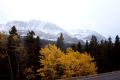
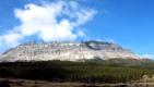
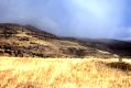
Entering Glacier National Peace Park in MT. Bright foliage and misty mountains with an invisible glacier
--Click to Enlarge--
Up in Glacier
--Click to Enlarge--
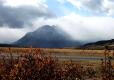
Another view of Glacier park
--Click to Enlarge--
All of the Montana highways have a posted 70 mph speed limit. There are sometimes stretches along our route where we could go for hundreds of yards between 40 mph sinusoidal curves. Even without those tighter bends, the speed that felt safe was usually slower. Karen and I decided that they should post "If you dare" below the "70" signs.
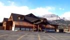
Boarding up for the winter in St. Mary. You are looking at the main stopping place!
--Click to Enlarge--
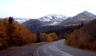
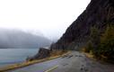
Fun winding, wet roads without guardrails
--Click to Enlarge--
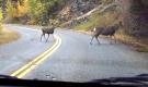
5 deer
--Click to Enlarge--
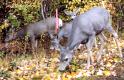
4 deer
--Click to Enlarge--
We stopped in St. Mary's for gas. It was being boarded up for its closing day, today. We actually slipped into the restrooms as a crew was nailing up the blizzard boards, about ½ hour from completely sealing it up. All the other buildings, including 2 of the 3 gas stations were already boarded up. Much of this trip is a simple combination of barely-made-it and just-missed-it.
Banded mountain with cloud and rainbow. Yes, in the lower right against the trees!
--Click to Enlarge--
I liked the banded mountain in the mist behind the orange bushes in the sun. The canadian border zone has some nice scenery
--Click to Enlarge--
We drove up the Going to the Sun road from St. Mary's to the Jackson Glacier overlook. There were gaps in the rain big enough to see the mountains, and we think we saw the particular greenish-white patch that marks Jackson Glacier. I’m wondering what the difference is between a simple snow-capped mountain, and a glacier. The border crossing on MT 17 in the park is closed for the season, but there is another one out on U.S. 89 and Alberta 2. So we drove over to that crossing.
Entering Alberta, Canada:
Canadian Border. I was taken by how vivid the flags were flapping against the sky
--Click to Enlarge--

A view of Canadian rolling rairie and jagged skyline. Note the squarish mountain
--Click to Enlarge--
We got stopped at the border! We had to "park on the left and go upstairs". Karen was quite put out. I was amused. I figured that they were bored, and we were in no hurry. They took our Missouri licenses into the back and did some computer magic. The young man wouldn’t drop his (Mounty) cop face and tell us what he’d found, but he let us go without having our car searched. This was good, because when the first guard asked if we had any alcohol, Karen said, "No." We had one bottle of beer somewhere in our voluminous backseat collection of comestibles. Probably they stopped us because, when asked if we had any weapons, I said that I thought that there was a pocketknife somewhere in the car. Or maybe it was my green Uni-bomber hoodie and wild hair.
We stopped for more food at the Carriage Mall IGA in Cardston just over the Canadian border. They took a U.S. $50 and gave us about $55 Canadian in change for our $7 purchase.
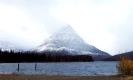
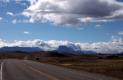
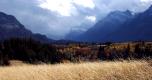
A valley view and disappearing mountains in Waterton Peace Park (the north half of Montana's Glacier Park)
--Click to Enlarge--
Rainbow. This is not just grass and mountains. The top of the rainbow is in the center of the picture.
--Click to Enlarge--
Onward we drove to Red Rock Canyon in Waterton Nat'l Park. The Alberta roads in the park are narrower than their U.S. counterparts, and had few of those view-obstructing rails to prevent careless travelers from reenacting the final scene in Thelma and Louise. Think of it as evolution in action, I guess.
A typical sanitary facility on the Canadian roadside. They are less fancy than those in the U.S, but they are Everywhere!
--Click to Enlarge--

I was impressed by the glow of that tiny pair of birch trees in that little valley notch between dark mountains.
--Click to Enlarge--

On both drives into Glacier (one in each country), we saw rainbows on the hills. It was partly sunny in the low areas, and raining as one got higher. Subtle arcs of color tinted the trees and cliffs to the west in the morning, and to the northeast in the afternoon.
At the Waterton visitors center, a ranger was prepping "Closed for the Season" signs: Today was the last day the visitor's center would be open for the year.
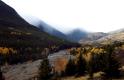
Where the color ends and the dark conifers begin at the feet of majestic banded mountains.
--Click to Enlarge--
This Tyrolean apparition is across from the Kilmorey Lodge at which we had a Saskatoon Berry Pie break
--Click to Enlarge--

Kilmorey Lodge restaurant had paper grouse decorating their ceiling fans. We'd been seeing the real things by the road since we'd crossed the border
--Click to Enlarge--

We stopped on our way out at the Kilmorey Lodge for coffee and Saskatoon berry pie. Karen loves these oddball berry pies. I saw more modern windmills between Pincher Creek and Cowley along the Crow's Nest Highway. Up here, we saw moose and pheasants, while before we saw only deer and antelope. We passed the (infamous) Hillcrest Mine on the way up to Crow’s-nest Pass. We know it mostly from the Paul and Win Grace and Family performance of the ballad.
Entering British Columbia, Canada: Our first crossing of the continental divide on this trip.
We stopped at the comparatively primitive East Kootenay rest area on the way down from the pass, and stopped for the night in Sparwood at the Black Nugget Motor Inn where highway 3 hits 43. This is coal territory: First, remove the trees, then the soil, then the rock, and finally the coal. This is mountaintop removal mining. They asked us if we were having dinner there when we checked in, and were quite surprised when we said, no. We found out the next morning that it was Canadian Thanksgiving, and we'd turned down the annual feast! Oh, well. Add it to my list of so many regrets involving declining offers without understanding them.
Once in the room, I spent an hour trying to IR sync my new (from a yard sale) Palm Pilot to my PC, and failing. KJ became quite pissed with me: She was hoping for a cozy in-room dinner. Oh, well. I finally got it to work while Karen took a relaxing bath. I have no idea what magical sequence was the variation on the explicit instructions necessary to get this to work. I usually figured it out faster, though. It turns out that there is a driver conflict (In Windows, surprise!).
Even up in the coal mining regions of Canada, they believe in using renewable energy. Note the Nordex \(http://www.nordex-online.com/_e/index.html\) Wind Turbine
--Click to Enlarge--

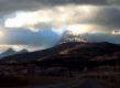
I'm a sucker for dramatic lighting. This is heading down from the Crow's Nest Pass into British Columbia.
--Click to Enlarge--
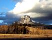
Look at the mountain. Vivid scenery is worth the drive
--Click to Enlarge--
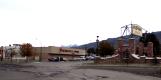
OverWaitea Foods? This is Sparwood, BC, a town whose purpose is to support the strip mining of the nearby coal-bearing mountains
--Click to Enlarge--