10/23/04: From Ute Mountain to Cortez, Geology and Election Year Politics
We had the breakfast buffet at the Ute Mountain Casino, and got on the road by 10.
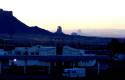
Another sunrise view onthe res. I like the line of receding volcanic plugs.
--Click to Enlarge--
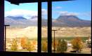
A last look out of our motel room window.
--Click to Enlarge--
We went down the 666 to Shiprock. Well, actually, 491. The innumerate numerologist Christians got the highway renamed in the last few years. Apparently the number that had been used for that highway for 60 years was now "too evil" for a reservation-spanning highway.
We made a wrong turn in Shiprock. This normally quiet town was bustling with a flea market, and many Indians (Navajo res) shading their eyes with big Kerry/Edwards signs along the street. I figured out my misdirection, and turned around and was heading back out in the right direction, when I heard sirens.
A convoy of several black SUV's, a tour bus labeled "KERRY / EDWARDS 2004" and more loud, black secret-service-like SUV's passed us. Obviously, we have passed the Kerry caravan. Kerry appeared today in the Navajo Nation.
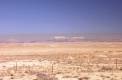
On the way to Shiprock, NM. The power plants on the res leave a smudge across the sky.
--Click to Enlarge--
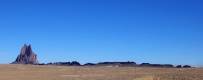
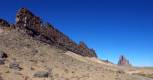
Shiprock, and its train, show clearly how the ground had split open and allowed lava to ooze up, and in one place to form a textbook cinder cone. The cinders are all but gone.
--Click to Enlarge--
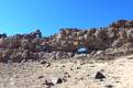
I had to climb up onto the lava extrusion and have a look along it.See karen below?
--Click to Enlarge--

See Dan walking up on the narrow ridge leading to Shiprock.
--Click to Enlarge--
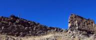
Anyway, we continued on to see the actual Ship rock. This is another formation like the Devil's Tower; a frozen magma core from a volcano with the ash cone eroded away. But to me, the interesting feature was a vane of basalt stretching away from it, like an ancient fort wall across the landscape. We stopped and climbed around on this wall. In places, you could even see the old limestone that had split to let this lava rise and form this thin vein of a vane.
A view along this volcanic wall toward Shiprock
--Click to Enlarge--
Dan poses in a (very windy, cold) window in the volcanic wall trailing from shiprock.
--Click to Enlarge--
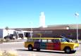
After this, we headed to Farmington. We took the "Historic Downtown" road and found the Visitor's Center. There is a nice historical and petrological museum in there. A fun "Well Bore" ride, where you are sealed in a moving room surrounded by video monitors and taken on a virtual ride down an oil well shaft. It had a nice display of the technologies used for identifying the layers of rock, explaining how they map all the rock strata across the country.
In Farmington, NM, there is a surpisingly good museum. Petroleum funded, and historically interesting. The Limoseum outside is a genuine Yellow Cab from the early 1960's
--Click to Enlarge--
After that, we tried to get back to U.S. 64, but found ourselves routed toward Aztec. We didn't stop to see the ruins, but continued on toward the Navajo Dam, and then back down to 64. The countryside is high desert; brush and short trees. Winding scenic roads do take longer, but are a much better cross section of the country.
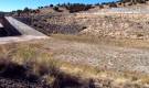
Looking up along the spillway and power plant of Navajo dam. The spillway was poured on natural rock, and the actual earthen dam is to the right.
--Click to Enlarge--
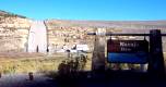
Drought explains why the warning buoys are lying in the dirt near the top of the spillway of Navajo Dam
--Click to Enlarge--
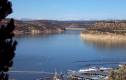
Navajo Lake. Distant mountins covered in snow. Water level obviously dozens of feet below normal.
--Click to Enlarge--
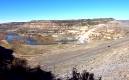
Looking down the earth fill of Navajo Dam back toward the spillway we saw a few pictures ago.
--Click to Enlarge--
We were exhausted as we pulled into the Chama, NM Visitor's center at 5 to 5:00 (7800 ft). We got some hotel info, and went to the first motel. They sent us to another, closer to town, that had WiFi. We arrived and checked in for less than the non-WiFi motel charged. But, the network was down.
I offered my assistance, and got the network back up, but the internet wasn't doing well. I suspect that I could have fixed it had they kept the PPPoE information on the premises.But the manager said that the owner keeps all of that stuff at home, and he is not to be bothered. Oh, well. Local calls are $0.50, plus the $0.10/min that the AOL 800 number needs.